Prior to the Norman Conquest of 1066 the municipal area of Chichester is not known.
From the late 9th century, Alfred had founded his network of Saxon burhs. These lay at the centre of Alfred’s reformed military defence system and were distributed at strategic points throughout the kingdom. Many were former Roman towns, the largest of which was Winchester, where the stone walls were repaired and ditches added. Chichester was part of this scheme.
There were thirty-three burhs in total, spaced approximately 30 kilometres (19 miles) apart, enabling the military to confront attacks, mainly from the Vikings, anywhere in the kingdom within a single day. It is likely that the chief parish of St. Peter Subdeanery, now [1935] known as St. Peter the Great, together with the subordinate parishes of the churches within the walls and those of the churches of St. Pancras and St. Bartholomew Without (meaning outside of the walls), represent the municipal district that was served by the Saxon minster of St. Peter of Chichester.
In 1260 the limits of the city were more carefully defined. It was then stated that the King of the Romans (Richard, Earl of Cornwall) held no control beyond a distance of 30ft outside the walls, that is, to the width of the great ditch. All tenements beyond the ditch were outside his liberty and jurisdiction, and the bailiffs of the city could not exercise their office there.
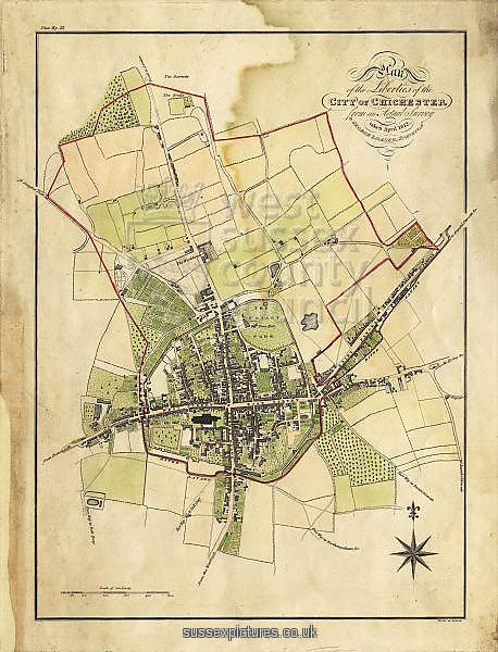
At some time after 1278 the city boundaries were considerably extended to the north. At the time of the new boundary of 1832 this northern area was retained intact, but the limits of the city were extended to the west, south and east. The boundaries were again extended in 1893 to include parts of the parishes of Rumboldswyke, Oving, St. Pancras, St. Bartholomew, All Saints, St. Peter Subdeanery, and St. James (extra-parochial district), and then in 1895 to include further parts of the parishes of St. Peter Subdeanery, St. Bartholomew, and St. Pancras. The city was formerly divided into ten wards, two for each of the four main streets, together with wards for the Pallant and the Vintry, which latter included St. Mary’s Hospital and the Grey Friars, but in 1896 the number of wards was reduced to three.
In 1753 all the eight parishes of the city had been united for purposes of Poor Law administration and the guardians of the poor were empowered to light the city and for a distance of 400 yards from the walls (roughly down to the modern junction with Parklands).
This text is the second in a monthly series of five about the suburb of St Bartholomew’s Without in the wider context of the development of the City of Chichester. It is drawn from an edited extract of a 1935 publication (details below). As such it has kept a centuries-old way of talking about Chichester where the city walls, gates, ditch and parishes defined our boundaries, untrammelled by the modern changes that not much more than five years later would come finally to disrupt the millennial harmonies of our cityscape.
Sources:
Main body of text – GB Historical GIS / University of Portsmouth, Chichester St Bartholomew CP/AP through time | Census tables with data for the Parish-level Unit, A Vision of Britain through Time. URL: http://www.visionofbritain.org.uk/unit/10287480
Victoria County History Publication A History of the County of Sussex: Volume 3 Author L.F. Salzman (editor) Year published 1935 Pages 71-82. URL: http://www.british-history.ac.uk/report.aspx?compid=41659