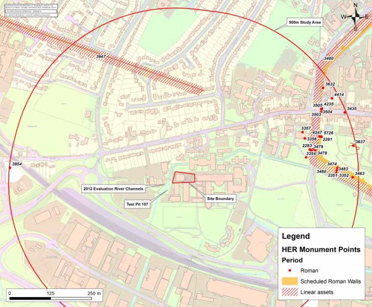
This article forms part of a series on the archaeology of Westgate and is adapted with their permission from an archaeological desk-based assessment prepared by SLR Consulting Ltd on behalf of Chichester College in 2013. The numbers on the map refer to objects mentioned in the text below that have been found and registered in the Historic Environment Record (HER) for Chichester District.
The Roman Period (1st – 5th centuries AD)
Thirty one non-designated assets and a single designated asset from this period are recorded within 500 metres of the College.
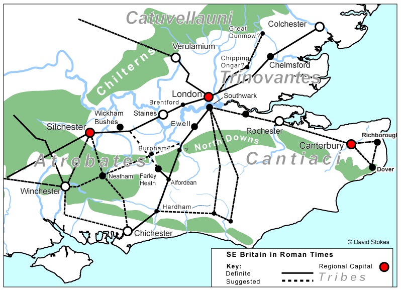
The initial phase of military occupation in Chichester immediately following the invasion of 43 AD was short-lived. Excavations at both Chichester and the harbour area of Fishbourne attest to the presence of the II Legion for a period of perhaps no more than a few years. In the later 1st century and well into the 2nd, civic development of Roman Chichester (Noviomagus Regnensium) took place, with extensive landscaping and construction on top of pre-existing buildings, but following the original grid of streets laid out by the army before them.
The City Walls
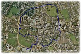
The scheduled City Walls represent the earliest designated structure in the City, although only fragments of Roman work and some of the rampart remain beneath later medieval and post-medieval additions. The Roman walls were probably constructed before the end of the 2nd century AD, the south-western corner of the fortified area passing within 50m of the college grounds on the eastern side of Avenue de Chartres.
The walls were encircled by a series of defensive ditches (HER 3480), added perhaps in response to the threat of invasion by Germanic raiders. The ditches were constructed in two phases. The first phase has been dated to around 200 AD when a rampart faced with a flint wall was constructed, with two ‘V’ shaped ditches surrounding it. The inner ditch was approximately 6m from the wall, the outer approximately 16m. The second phase of ditch construction took place in the mid-4th century, and comprised a bastion constructed over the line of the silted-up inner ditch and a flat-bottomed ditch cut along the line of the earlier outer ditch.
There are sixteen records relating to investigations along the line of the defences around 400m to the east of Westgate and which are summarised below:
- The Roman foundations of the Palace Bastion were exposed (HER 3351) and recorded in 1932, 1959 and 1985, and a possible robbed out well (HER 3352) was found beneath the foundations of the Roman Bastion. A possible bastion (HER 3463) was found on the line of walls based on John Norden’s map of Chichester dated 1595. Excavation of a rampart in 1932 (HER 3474) uncovered tips of Roman demolition debris in structure of bank (including tiles, mortar, plaster, window glass, nails and pottery dated no later than 2nd century).
- The 1959 excavations on the line of defences uncovered the two ‘V’-shaped first phase ditches (HER 3478) and an uncovered flat-bottomed 4th century ditch HER 3479). These excavations also uncovered a non-defensive 1st century ditch beneath the later 2nd century inner-ditch (HER 3483). A section through the Roman bank was exposed when a car-park wall collapsed in 1966 near to the West Gate (HER 3488).
- The 1963 excavations at the West Gate uncovered the foundations of a medieval gate (HER 3501), leading to a speculative suggestion that the Roman Gate must lie beneath the road. The excavation north of the West Gate (HER 3503) uncovered occupation and metalworking debris below a defensive bank and wall. Observation was made in 1964 of possible dressed-stone footings for the Roman West Gate gatehouse in a service trench beneath the Westgate Road (HER 3504). An occupation layer, possibly a smithy, was discovered below the Roman wall and bank during excavations in 1963/4 (HER 3505).
- During an evaluation at 8 North Walls a section of the foundation/core of the City Wall was found (HER 3632). During the construction of a new twin culvert at Westgate a pit was found on the side of the river (HER 4235). Evidence of Roman occupation was seen during the winter of 1987/88 when a section was cut through the Chichester city defences along the Avenue de Chartres (HER 4247). And finally, in 1987, during the excavation of a section through the Roman rampart at the West Walls on Avenue de Chartres following a collapse, a section of metalled Roman street was exposed (HER 5726).
Roman Roads
Within the defended Roman settlement and within 500m of the college there are four non-designated assets associated with occupation. These comprise a mosaic floor (HER 3353), a Roman building with tessellated floor (HER 3435), a possible Roman building within the Bishops Palace garden (HER 3673) and occupation deposits near the northern walls (HER 4414).
Two Roman roads pass within 500m of Westgate. The first (HER 3947) is suggested by an earthwork shown as a field boundary on historic maps, which runs in a north-westerly direction from the West Gate. The line of the feature was traced in 1934 and, although no excavations have confirmed it, it is believed that an accompanying ditch was sufficient evidence to indicate that this had formerly been a Roman road. The second is not recorded, but runs east-west 95m to the north of the college and represents the main Roman road leading from the western city gate to the palace at Fishbourne 1km away.
There is also evidence for occupation outside the western city walls during the early Roman period. An excavation in 1959 on the line of Avenue de Chartres uncovered the remains of an east-west aligned street, to the north of which was a late 1st/early 2nd century building constructed from flint and bonded with clay (HER 2281). The location of this street (to the south of, and parallel with, Westgate) was confirmed by excavation in 1961 (HER 2282). A timber lined well nearby was found to contain items from a ladies’ toilet set, including a small square green glass jar and an earthenware pot (HER 2283).
A second Roman street was discovered in 1987 on the line of Avenue de Chartres, running north-south and flanked by the mortar floors and post-holes of timber-framed buildings (HER 2291). The street, which contained wheel ruts, was dated to the late 1st century on the basis of a coin recovered from the road make-up, struck around 91-96 AD. The street had subsequently been buried by the town defences in the 2nd century. The majority of excavations undertaken outside the West Gate were carried out in 1985 and 1987 at the site of the former Theological College, 350m to the northeast of the college on the northern side of the River Lavant (HER 3354 to 57).
A Roman Cemetery
Three records relate to these excavations. At the northern end of the site a Roman inhumation cemetery was discovered containing 43 skeletons, one in a lead coffin. The physical extent of the cemetery is unclear, though it is known that it does not extend further to the east than the Avenue de Chartres. It is thought that the uncovered remains probably represent a small sample of a much larger burial ground, and complements other known cemeteries outside the North and East Gates.
To the south of the cemetery were the remains of two late-1st / early-2nd century timber buildings, a ditch and a gravel extraction pit. Whether the former Theological College site represents the outer western limit of the early Roman town is unclear. It is known that the 1st / 2nd century settlement extended over ¼ mile southward from the South Gate, and that buildings were constructed outside the city walls in the 3rd and 4th centuries, however excavations further along Westgate have not yielded conclusive evidence for Roman activity and there are no other recorded stratified Roman deposits in the study area.
There are isolated findspots of Roman artefacts within the study area, that of a clay figurine found on the line of the southern wall (HER 3021) and occupation debris found during excavations on Fishbourne Road in 1996 (HER 3954). Archaeological monitoring conducted during geotechnical investigations at Chichester College in 2008 identified a layer of Roman debris containing roof tile and pottery on the eastern side of the River Lavant. No significant deposits were identified immediately to the north.
The River Lavant
In 2012 an archaeological evaluation was carried out by West Sussex Archaeology at the site of the recently redeveloped college G Block, to the west of the River Lavant. This uncovered two former stream channels containing Roman artefacts. It is postulated that the artefacts seen in the test pit may relate to a further stream channel, though the depth of the artefacts was notably shallower at 1.2m below the adjacent ground surface as opposed to around 2m depth at G Block. Excavations elsewhere in the city have demonstrated that the River Lavant was not diverted to its present course around the city walls until the late 9th century AD, indicating that these river or stream channels are not former channels of the Lavant.